Tag Archives: LCRA

Green comet

Lower Colorado River Authority meteorologist Bob Rose notes this at spaceweather.com:

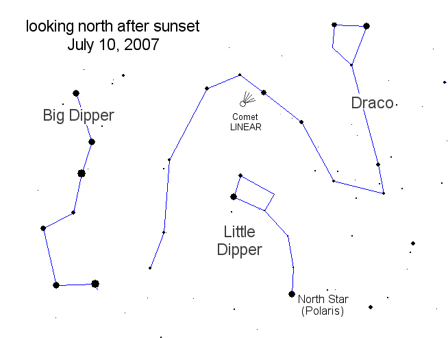
"Grab your binoculars. Pretty green Comet Linear VZ13 is gliding through the constellation Draco this week. It’s too dim for the unaided eye, [but some say a 7X35 binocular will do just fine]. To find [VZ13] go outside after sunset and face north; the comet lies just a few star hops from Polaris."

It helps to be high enough to see the horizon. A finder map here which is dated the 10th but should be helpful through tomorrow night. 

Up she rises

Lake Travis, still taking in water from the rains in the western Hill Country, isn’t satisifed with 700 feet above msl:

"LCRA now forecasts that Lake Travis will peak between 701 and 702 feet msl based on rain that has already fallen. However, more rain is expected today throughout the region. Be advised: If there is much additional rain, at a time when the lakes and river are already full, more floodgates may be opened with little or no notice."

Radar’s almost clear at this hour, but that’s expected to change by dawn. Wait and see.

UPDATE By late Wednesday, the forecast was 703 feet msl. Not much on radar, except some really powerful storms around Bay City, southwest of Galveston. 

Perpetual rain

It’s back. After a few days rest, rain (heavy at times) is back in the forecast. On the radar it’s all south and southeast of Austin, so far. Houston and Galveston are really getting pounded. My fingers are crossed that the watershed of the lakes doesn’t get a lot more. With Lake Travis already predicted to hit 701 feet above msl in a few days (the record is 710 in 1991) still more water would present a terrible problem for LCRA, boatowners and everyone who lives out there.

Lake Travis flag

Flagpole.JPG

This is what almost 18 feet above normal looks like in the Cypress Creek channel at Lake Travis. The floating docks on either side rose, the flagpole didn’t. And the cleat for the flag’s halyard being well underwater, nobody’s going to be taking it down soon. Especially when LCRA says almost 3 inches of rain Saturday in the Colorado River watershed around San Saba will push the lake to 701 feet in a few days. It could be weeks before things are back to semi-normal.

Lake on the rise

LCRA automated site shows Lake Travis up to 697.85 feet above mean sea level, or almost seventeen feet above full. On the way to 700 by Monday is the latest prediction. Believe I’ll visit tomorrow, to see what I can see and what can be shown here.

Runup

LakeTravis.JPG

 LCRA graphic of Lake Travis on the way up, flooding some homes, isolating some marinas, and covering some private docks, with up to another 5 feet expected, and more possible. By 11:30 p.m., it was at 693.30.

Catastrophe 2007

LCRA is now projecting that Lake Travis will rise to almost 697 feet above mean sea level by tomorrow afternoon, despite having four flood gates open. That would be sixteen feet above full. Have to check but that might be a record height. That’s just from the rain that’s fallen so far. More rain is expected out there tonight.

UPDATE LCRA has closed the lake to recreational boating. City of Austin has, likewise, closed its waterways. Debris, etc.